(From NHK)
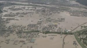
Over 200 people have died in floods and landslides triggered by the recent torrential rain in western Japan in July 2018.
It is the highest death toll caused by rainfall that Japan has seen in more than four decades.
In Japan, 1300 municipalities released the hazard maps.
They namely pinpoint locations at risk of floods or landslides.
There was a time when the disclosure of hazard information raised many eyebrows as fanning people’s fears and lowering property values.
But after we saw the recent worst flooding disaster in west of Japan in four decades, this is no longer the case.
In the Mabicho district of Kurashiki, Okayama Prefecture, the flooded areas reportedly corresponded exactly to what the hazard map showed. To date, more than 40 bodies have been recovered from severely flooded residential neighborhoods, now blanketed with mud.


